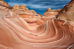
The Wave, an area of fantastic eroded sandstone featuring beautiful swirls, wild colors, countless striations, and bizarre shapes set amidst the dramatic surrounding North Coyote Buttes of Arizona and Utah. The sandstone formations of the North Coyote Buttes, including the Wave, date from the Jurassic period. Managed by the Bureau of Land Management, the Wave is located in the Paria Canyon-Vermilion Cliffs Wilderness and is accessible on foot by permit only.
Location: North Coyote Buttes, Paria Canyon-Vermilion Cliffs Wilderness, Arizona
Image ID: 20605
Location: North Coyote Buttes, Paria Canyon-Vermilion Cliffs Wilderness, Arizona
Image ID: 20605
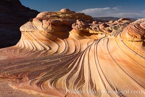
The Second Wave at Sunset, North Coyote Buttes. The Second Wave, a curiously-shaped sandstone swirl, takes on rich warm tones and dramatic shadowed textures at sunset. Set in the North Coyote Buttes of Arizona and Utah, the Second Wave is characterized by striations revealing layers of sedimentary deposits, a visible historical record depicting eons of submarine geology.
Location: North Coyote Buttes, Paria Canyon-Vermilion Cliffs Wilderness, Arizona
Image ID: 20606
Location: North Coyote Buttes, Paria Canyon-Vermilion Cliffs Wilderness, Arizona
Image ID: 20606
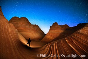
The Wave at Night, under a clear night sky full of stars. Photographer is illuminating the striated rocks with a small handheld light. The Wave, an area of fantastic eroded sandstone featuring beautiful swirls, wild colors, countless striations, and bizarre shapes is set amidst the dramatic surrounding North Coyote Buttes of Arizona and Utah. The sandstone formations of the North Coyote Buttes, including the Wave, date from the Jurassic period. Managed by the Bureau of Land Management, the Wave is located in the Paria Canyon-Vermilion Cliffs Wilderness and is accessible on foot by permit only.
Location: North Coyote Buttes, Paria Canyon-Vermilion Cliffs Wilderness, Arizona
Image ID: 28620
Location: North Coyote Buttes, Paria Canyon-Vermilion Cliffs Wilderness, Arizona
Image ID: 28620
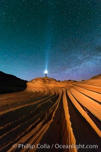
The Second Wave at Night. The Second Wave, a spectacular sandstone formation in the North Coyote Buttes, lies under a sky full of stars.
Location: North Coyote Buttes, Paria Canyon-Vermilion Cliffs Wilderness, Arizona
Image ID: 28627
Location: North Coyote Buttes, Paria Canyon-Vermilion Cliffs Wilderness, Arizona
Image ID: 28627
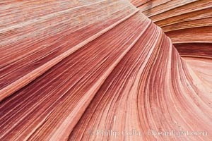
The Wave, an area of fantastic eroded sandstone featuring beautiful swirls, wild colors, countless striations, and bizarre shapes set amidst the dramatic surrounding North Coyote Buttes of Arizona and Utah. The sandstone formations of the North Coyote Buttes, including the Wave, date from the Jurassic period. Managed by the Bureau of Land Management, the Wave is located in the Paria Canyon-Vermilion Cliffs Wilderness and is accessible on foot by permit only.
Location: North Coyote Buttes, Paria Canyon-Vermilion Cliffs Wilderness, Arizona
Image ID: 20607
Location: North Coyote Buttes, Paria Canyon-Vermilion Cliffs Wilderness, Arizona
Image ID: 20607
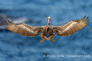
A California Brown Pelican flying over the Pacific Ocean, spreads its large wings wide to slow down as it slows to land on seacliffs in La Jolla. Adult winter breeding plumage with yellow head, red throat and brown hindneck.
Species: Brown Pelican, Pelecanus occidentalis, Pelecanus occidentalis californicus
Location: La Jolla, California
Image ID: 40806
Species: Brown Pelican, Pelecanus occidentalis, Pelecanus occidentalis californicus
Location: La Jolla, California
Image ID: 40806
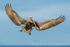
Brown pelican in flight, spreading wings wide to slow in anticipation of landing on seacliffs.
Species: Brown Pelican, Pelecanus occidentalis, Pelecanus occidentalis californicus
Location: La Jolla, California
Image ID: 28333
Species: Brown Pelican, Pelecanus occidentalis, Pelecanus occidentalis californicus
Location: La Jolla, California
Image ID: 28333
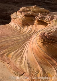
The Second Wave at Sunset, Vermillion Cliffs. The Second Wave, a curiously-shaped sandstone swirl, takes on rich warm tones and dramatic shadowed textures at sunset. Set in the North Coyote Buttes of Arizona and Utah, the Second Wave is characterized by striations revealing layers of sedimentary deposits, a visible historical record depicting eons of submarine geology.
Location: North Coyote Buttes, Paria Canyon-Vermilion Cliffs Wilderness, Arizona
Image ID: 28613
Location: North Coyote Buttes, Paria Canyon-Vermilion Cliffs Wilderness, Arizona
Image ID: 28613
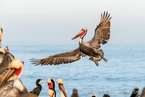
California brown pelican in flight, spreading wings wide to slow in anticipation of landing on seacliffs. Note the classic winter breeding plumage, with bright red throat, yellow and white head and neck, and brown hind neck. Other pelicans and cormorants at the periphery of the image hint at how crowded the cliff is with other birds.
Species: Brown Pelican, Pelecanus occidentalis, Pelecanus occidentalis californicus
Location: La Jolla, California
Image ID: 36679
Species: Brown Pelican, Pelecanus occidentalis, Pelecanus occidentalis californicus
Location: La Jolla, California
Image ID: 36679
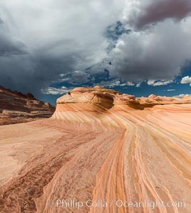
The Second Wave at sunset. The Second Wave, a curiously-shaped sandstone swirl, takes on rich warm tones and dramatic shadowed textures at sunset. Set in the North Coyote Buttes of Arizona and Utah, the Second Wave is characterized by striations revealing layers of sedimentary deposits, a visible historical record depicting eons of submarine geology.
Location: North Coyote Buttes, Paria Canyon-Vermilion Cliffs Wilderness, Arizona
Image ID: 28614
Location: North Coyote Buttes, Paria Canyon-Vermilion Cliffs Wilderness, Arizona
Image ID: 28614
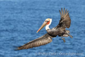
California brown pelican in flight, spreading wings wide to slow in anticipation of landing on seacliffs. Adult winter non-breeding plumage.
Species: Brown Pelican, Pelecanus occidentalis, Pelecanus occidentalis californicus
Image ID: 37408
Species: Brown Pelican, Pelecanus occidentalis, Pelecanus occidentalis californicus
Image ID: 37408
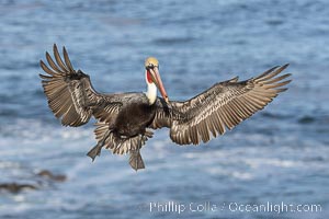
California Brown Pelican in flight, spreading wings wide to slow before landing on cliffs, Pelecanus occidentalis.
Species: Brown Pelican, Pelecanus occidentalis, Pelecanus occidentalis californicus
Location: La Jolla, California
Image ID: 38839
Species: Brown Pelican, Pelecanus occidentalis, Pelecanus occidentalis californicus
Location: La Jolla, California
Image ID: 38839
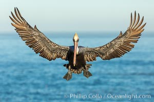
California brown pelican in flight, braking to land on seacliffs.
Species: Brown Pelican, Pelecanus occidentalis, Pelecanus occidentalis californicus
Location: La Jolla, California
Image ID: 36726
Species: Brown Pelican, Pelecanus occidentalis, Pelecanus occidentalis californicus
Location: La Jolla, California
Image ID: 36726
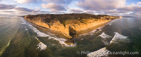
Flat Rock and Torrey Pines Seacliffs at Sunset, aerial photo.
Location: Torrey Pines State Reserve, San Diego, California
Image ID: 38227
Location: Torrey Pines State Reserve, San Diego, California
Image ID: 38227
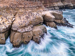
Brown Pelicans on Goldfish Point in La Jolla, time exposure blurs the large waves, aerial photograph. In the summer we used to jump off the cliff (the "Clam") in front of the twin cave entrances seen at middle-right.
Species: Brown Pelican, Pelecanus occidentalis, Pelecanus occidentalis californicus
Location: La Jolla, California
Image ID: 38865
Species: Brown Pelican, Pelecanus occidentalis, Pelecanus occidentalis californicus
Location: La Jolla, California
Image ID: 38865
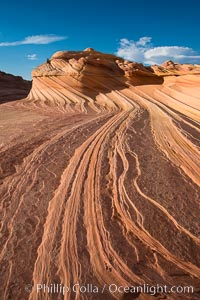
The Second Wave at Sunset, Vermillion Cliffs. The Second Wave, a curiously-shaped sandstone swirl, takes on rich warm tones and dramatic shadowed textures at sunset. Set in the North Coyote Buttes of Arizona and Utah, the Second Wave is characterized by striations revealing layers of sedimentary deposits, a visible historical record depicting eons of submarine geology.
Location: North Coyote Buttes, Paria Canyon-Vermilion Cliffs Wilderness, Arizona
Image ID: 28619
Location: North Coyote Buttes, Paria Canyon-Vermilion Cliffs Wilderness, Arizona
Image ID: 28619
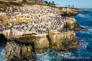
Brown Pelicans gather in large numbers on coastal cliffs, Goldfish Point near the Clam in La Jolla. Aerial photograph.
Species: Brown Pelican, Pelecanus occidentalis, Pelecanus occidentalis californicus
Location: La Jolla, California
Image ID: 37954
Species: Brown Pelican, Pelecanus occidentalis, Pelecanus occidentalis californicus
Location: La Jolla, California
Image ID: 37954
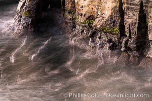
Sea Caves, the famous La Jolla sea caves lie below tall cliffs at Goldfish Point. Sunny Jim Cave. Sunrise. Sea gulls floating int he water blur in this time exposure.
Location: La Jolla, California
Image ID: 37469
Location: La Jolla, California
Image ID: 37469
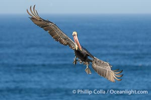
A California Brown Pelican flying over the Pacific Ocean, spreads its large wings wide to slow down as it banks, turns in midair, to land on seacliffs in La Jolla. Winter adult non-breeding plumage.
Species: Brown Pelican, Pelecanus occidentalis californicus, Pelecanus occidentalis
Location: La Jolla, California
Image ID: 39791
Species: Brown Pelican, Pelecanus occidentalis californicus, Pelecanus occidentalis
Location: La Jolla, California
Image ID: 39791
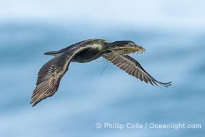
Brandt's Cormorant in flight carrying surfgrass for nest building, ocean background.
Species: Brandt's Cormorant, Phalacrocorax penicillatus
Location: La Jolla, California
Image ID: 40870
Species: Brandt's Cormorant, Phalacrocorax penicillatus
Location: La Jolla, California
Image ID: 40870
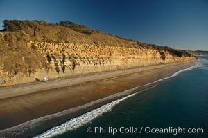
Torrey Pines seacliffs, rising up to 300 feet above the ocean, stretch from Del Mar to La Jolla. On the mesa atop the bluffs are found Torrey pine trees, one of the rare species of pines in the world.
Location: Torrey Pines State Reserve, San Diego, California
Image ID: 22285
Location: Torrey Pines State Reserve, San Diego, California
Image ID: 22285
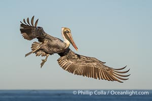
A California Brown Pelican flying over the Pacific Ocean, spreads its large wings wide to slow down as it banks, turns in midair, to land on seacliffs in La Jolla. Winter adult non-breeding plumage.
Species: Brown Pelican, Pelecanus occidentalis californicus, Pelecanus occidentalis
Location: La Jolla, California
Image ID: 39789
Species: Brown Pelican, Pelecanus occidentalis californicus, Pelecanus occidentalis
Location: La Jolla, California
Image ID: 39789
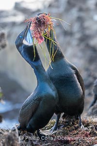
Nesting Pair of Brandt's Cormorants exchanging red algae and surf grass nesting material, on La Jolla Cliffs.
Species: Brandt's cormorant, Phalacrocorax penicillatus
Location: La Jolla, California
Image ID: 40871
Species: Brandt's cormorant, Phalacrocorax penicillatus
Location: La Jolla, California
Image ID: 40871
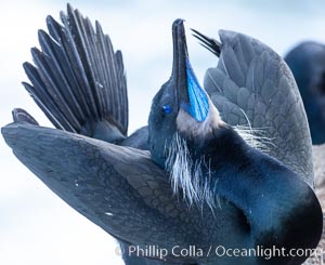
Male Brandt's Cormorant Skypointing, Courtship Display, Breeding Plumage with blue throat and white pin-feathers, La Jolla. Skypointing is an interesting courtship behavior that many birds practice. Among Brandt's Cormorants the male performs this, likely as a way of attracting a mate to the nest he has built by showing off his striking blue throat. He tips his head backward showing off his striking blue throat, and partially raises his wings. Seen here on seacliffs above the ocean.
Species: Brandt's cormorant, Phalacrocorax penicillatus
Image ID: 36801
Species: Brandt's cormorant, Phalacrocorax penicillatus
Image ID: 36801
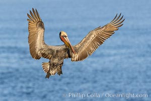
Brown pelican in flight, spreading wings wide to slow in anticipation of landing on seacliffs.
Species: Brown Pelican, Pelecanus occidentalis, Pelecanus occidentalis californicus
Location: La Jolla, California
Image ID: 37682
Species: Brown Pelican, Pelecanus occidentalis, Pelecanus occidentalis californicus
Location: La Jolla, California
Image ID: 37682
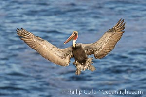
Brown pelican in flight with wings spread wide, slowing as it returns from the ocean to land on seacliffs, adult winter non-breeding plumage.
Species: Brown Pelican, Pelecanus occidentalis, Pelecanus occidentalis californicus
Location: La Jolla, California
Image ID: 38584
Species: Brown Pelican, Pelecanus occidentalis, Pelecanus occidentalis californicus
Location: La Jolla, California
Image ID: 38584
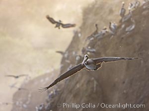
Brown Pelicans Flying Along Sheer Ocean Cliffs, rare westerly winds associated with a storm allow pelicans to glide along La Jolla's cliffs as they approach shelves and outcroppings on which to land. Backlit by rising sun during stormy conditions.
Species: Brown Pelican, Pelecanus occidentalis, Pelecanus occidentalis californicus
Location: La Jolla, California
Image ID: 38867
Species: Brown Pelican, Pelecanus occidentalis, Pelecanus occidentalis californicus
Location: La Jolla, California
Image ID: 38867
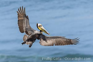
California Brown pelican in flight, La Jolla, wings outstretched, spreading wings wide to slow in anticipation of landing on seacliffs. Adult winter breeding plumage colors.
Species: Brown Pelican, Pelecanus occidentalis, Pelecanus occidentalis californicus
Location: La Jolla, California
Image ID: 38884
Species: Brown Pelican, Pelecanus occidentalis, Pelecanus occidentalis californicus
Location: La Jolla, California
Image ID: 38884

Sunset at Dead Horse Point Overlook, with the Colorado River flowing 2,000 feet below. 300 million years of erosion has carved the expansive canyons, cliffs and walls below and surrounding Deadhorse Point.
Location: Dead Horse Point State Park, Utah
Image ID: 27823
Panorama dimensions: 5303 x 17695
Location: Dead Horse Point State Park, Utah
Image ID: 27823
Panorama dimensions: 5303 x 17695
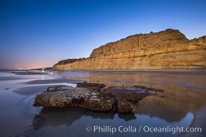
Torrey Pines Cliffs lit at night by a full moon, low tide reflections.
Location: Torrey Pines State Reserve, San Diego, California
Image ID: 28461
Location: Torrey Pines State Reserve, San Diego, California
Image ID: 28461