Guadalupe Island at sunrise, panorama. Volcanic coastline south of Pilot Rock and Spanish Cove, near El Faro lighthouse.
Location: Guadalupe Island (Isla Guadalupe), Baja California, Mexico
Image ID: 28758
Panorama dimensions: 4224 x 25926
Location: Guadalupe Island (Isla Guadalupe), Baja California, Mexico
Image ID: 28758
Panorama dimensions: 4224 x 25926

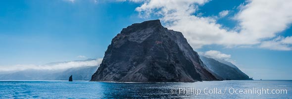
Punta Norte, the northern point of Guadalupe Island, viewed from the north. Punta Desfiladero (Blunt Point) and Roca Elefante are just visible at far right, and Roca Piloto (Pilot Rock) is see to the left of the island against the distant sweep of the cliffs that comprise the northeastern bight of the island, actually the rim of an enormous caldera.
Location: Guadalupe Island (Isla Guadalupe), Baja California, Mexico
Image ID: 28760
Panorama dimensions: 4595 x 13560
Location: Guadalupe Island (Isla Guadalupe), Baja California, Mexico
Image ID: 28760
Panorama dimensions: 4595 x 13560

Sunrise clouds and light, panorama, viewed from Guadalupe Island over the Pacific Ocean.
Location: Guadalupe Island (Isla Guadalupe), Baja California, Mexico
Image ID: 28759
Panorama dimensions: 4301 x 14369
Location: Guadalupe Island (Isla Guadalupe), Baja California, Mexico
Image ID: 28759
Panorama dimensions: 4301 x 14369

Guadalupe Island at sunrise, panorama. Volcanic coastline south of Pilot Rock and Spanish Cove, near El Faro lighthouse.
Location: Guadalupe Island (Isla Guadalupe), Baja California, Mexico
Image ID: 28757
Panorama dimensions: 6999 x 27905
Location: Guadalupe Island (Isla Guadalupe), Baja California, Mexico
Image ID: 28757
Panorama dimensions: 6999 x 27905