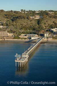
SIO Pier, Scripps Pier, La Jolla. The Scripps Institution of Oceanography research pier is 1090 feet long and was built of reinforced concrete in 1988, replacing the original wooden pier built in 1915. The Scripps Pier is home to a variety of sensing equipment above and below water that collects various oceanographic data. The Scripps research diving facility is located at the foot of the pier. Fresh seawater is pumped from the pier to the many tanks and facilities of SIO, including the Birch Aquarium. The Scripps Pier is named in honor of Ellen Browning Scripps, the most significant donor and benefactor of the Institution.
Location: Scripps Institution of Oceanography, La Jolla, California
Image ID: 22286
Location: Scripps Institution of Oceanography, La Jolla, California
Image ID: 22286
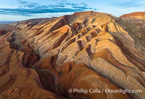
Aerial Photo of Raplee Ridge near Mexican Hat, Utah. Raplee Ridge is a spectacular series of multicolored triangular flatirons near the San Juan River. Often called "the Raplee Anticline" the geologic structure is in fact better described as a monocline, according to the Utah Geological Survey.
Location: Mexican Hat, Utah
Image ID: 39489
Location: Mexican Hat, Utah
Image ID: 39489
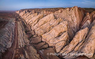
Aerial photo of the San Rafael Reef at dawn. A fold in the Earth's crust leads to this inclined section of the San Rafael Reef, at the eastern edge of the San Rafael Swell. Clearly seen are the characteristic triangular flatiron erosion patterns that typical this formation. The colors seen here arise primarily from Navajo and Wingate sandstone.
Location: Utah
Image ID: 39787
Location: Utah
Image ID: 39787
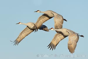
Sandhill cranes in synchronous flight side by side, matching their wingbeats perfect as they fly over Bosque del Apache NWR.
Species: Sandhill crane, Grus canadensis
Location: Bosque del Apache National Wildlife Refuge, Socorro, New Mexico
Image ID: 38723
Species: Sandhill crane, Grus canadensis
Location: Bosque del Apache National Wildlife Refuge, Socorro, New Mexico
Image ID: 38723
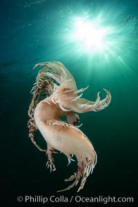
Dendronotus iris swimming nudibranch, Browning Pass, Vancouver Island.
Species: Dendronotus iris
Location: British Columbia, Canada
Image ID: 35275
Species: Dendronotus iris
Location: British Columbia, Canada
Image ID: 35275
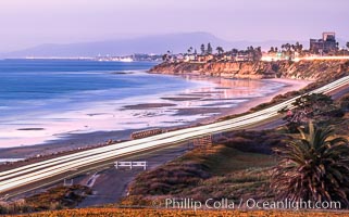
Carlsbad Coast Highway Sunset, from Terramar and North Ponto to Oceanside and Camp Pendleton. The smoke stack that marked the old Encina Power Plant was removed in 2021. Oceanside Pier is seen beautifully lit in the distance. Rising in the distance is San Onofre Mountain (1722') topped by a tall signal tower, one of the southern peaks in the Santa Ana Mountains.
Location: Carlsbad, California
Image ID: 37479
Location: Carlsbad, California
Image ID: 37479
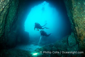
Two Divers in Huge Cavern, San Pedro Martir Island, Sea of Cortez.
Location: Isla San Pedro Martir, Sonora, Mexico
Image ID: 40389
Location: Isla San Pedro Martir, Sonora, Mexico
Image ID: 40389
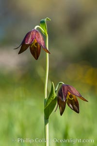
Chocolate lily growing among grasses on oak-covered hillsides. The chocolate lily is a herbaceous perennial monocot that is increasingly difficult to find in the wild due to habitat loss. The flower is a striking brown color akin to the color of chocolate.
Location: Santa Rosa Plateau Ecological Reserve, Murrieta, California
Image ID: 33151
Location: Santa Rosa Plateau Ecological Reserve, Murrieta, California
Image ID: 33151
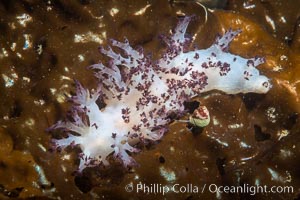
Red Nudibranch, Dendronotus rufus, Browning Pass, Vancouver Island.
Species: Red nudibranch, Dendronotus rufus
Location: British Columbia, Canada
Image ID: 35271
Species: Red nudibranch, Dendronotus rufus
Location: British Columbia, Canada
Image ID: 35271
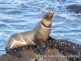
California sea lion entangled in fishing line, deep laceration around neck, Point La Jolla.
Species: California sea lion, Zalophus californianus
Location: La Jolla, California
Image ID: 40486
Species: California sea lion, Zalophus californianus
Location: La Jolla, California
Image ID: 40486

Carlsbad Coast at Sunset, Terramar and the Oceanside Pier, with Camp Pendleton and the San Onofre power plant in the distance on this incredibly clean and crisp evening view. Rising in the distance is San Onofre Mountain (1722') topped by a tall signal tower, one of the southern peaks in the Santa Ana Mountains.
Location: Carlsbad, California
Image ID: 37482
Panorama dimensions: 1106 x 3500
Location: Carlsbad, California
Image ID: 37482
Panorama dimensions: 1106 x 3500
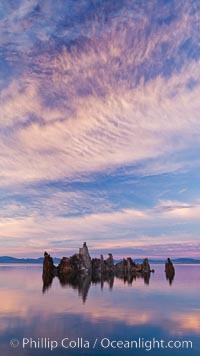
Mono Lake sunset, tufa and clouds reflected in the still waters of Mono Lake.
Location: Mono Lake, California
Image ID: 26977
Location: Mono Lake, California
Image ID: 26977
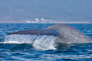
Blue whale and San Onofre Nuclear Power generating station, raising fluke prior to diving for food, fluking up, lifting its tail as it swims in the open ocean foraging for food.
Species: Blue whale, Balaenoptera musculus
Location: Dana Point, California
Image ID: 27337
Species: Blue whale, Balaenoptera musculus
Location: Dana Point, California
Image ID: 27337
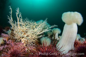
Basket Star and Giant Metridium anemone, Browning Pass, Vancouver Island.
Species: Basket star, Giant plumose anemone, Gorgonocephalus eucnemis, Metridium farcimen
Location: British Columbia, Canada
Image ID: 35287
Species: Basket star, Giant plumose anemone, Gorgonocephalus eucnemis, Metridium farcimen
Location: British Columbia, Canada
Image ID: 35287
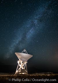
Radio telescope antenna, part of the Very Long Baseline Array (VLBA). The Very Long Baseline Array (VLBA) is a system of ten radio telescopes which are operated remotely from their Array Operations Center located in Socorro, New Mexico, as a part of the National Radio Astronomy Observatory (NRAO). These ten radio antennas work together as an array that forms the longest system in the world that uses very long baseline interferometry.
Location: Big Pine, California
Image ID: 28787
Location: Big Pine, California
Image ID: 28787
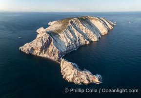
Isla San Pedro Martir at sunset with extensive forest of Cardon Cactus seen on the summit ridge of the island, aerial photo, Sea of Cortez, Mexico. San Pedro Martir Island and its marine life are, since 2002, part of the San Pedro Martir Biosphere Reserve, and is regarded as a natural laboratory of adaptive evolution, similar to that of the Galapagos Islands. It is home to 292 species of fauna and flora (both land-based and aquatic), with 42 species protected by Mexican law, and 30 listed on the Red List of Threatened Species. San Pedro Martir is also unique in the area for its year-round quantity of birds. The island is the only island in the area with a perpetually swirling cloud of sea birds. This is because the water around the island, has some of the most successful marine productivity in the world.
Location: Isla San Pedro Martir, Sonora, Mexico
Image ID: 40397
Location: Isla San Pedro Martir, Sonora, Mexico
Image ID: 40397
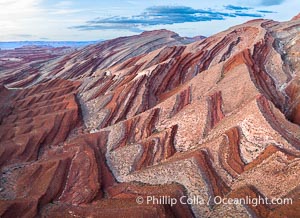
Aerial Photo of Raplee Ridge near Mexican Hat, Utah. Raplee Ridge is a spectacular series of multicolored triangular flatirons near the San Juan River. Often called "the Raplee Anticline" the geologic structure is in fact better described as a monocline, according to the Utah Geological Survey.
Location: Mexican Hat, Utah
Image ID: 39490
Location: Mexican Hat, Utah
Image ID: 39490
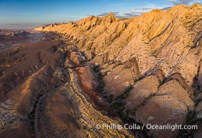
Aerial photo of the San Rafael Reef at dawn. A fold in the Earth's crust leads to this inclined section of the San Rafael Reef, at the eastern edge of the San Rafael Swell. Clearly seen are the characteristic triangular flatiron erosion patterns that typical this formation. The colors seen here arise primarily from Navajo and Wingate sandstone.
Location: Utah
Image ID: 39784
Location: Utah
Image ID: 39784
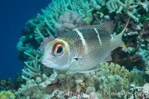
Humpnose Bigeye Bream, Monotaxis grandoculis, Fiji.
Location: Makogai Island, Lomaiviti Archipelago, Fiji
Image ID: 31348
Location: Makogai Island, Lomaiviti Archipelago, Fiji
Image ID: 31348
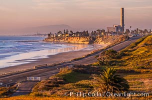
Carlsbad Coast Highway Sunset, Terramar and North Ponto to Oceanside with Camp Pendleton in the distance. Rising in the distance is San Onofre Mountain (1722') topped by a tall signal tower, one of the southern peaks in the Santa Ana Mountains.
Location: Carlsbad, California
Image ID: 35902
Location: Carlsbad, California
Image ID: 35902
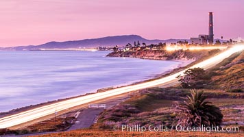
Sunset on Terra Mar and the Carlsbad coastline, looking north to Oceanside, Camp Pendleton and San Onofre. The Oceanside Pier, lit up at night, is seen further up the coast. Rising in the distance is San Onofre Mountain (1722') topped by a tall signal tower, one of the southern peaks in the Santa Ana Mountains.
Image ID: 36117
Image ID: 36117
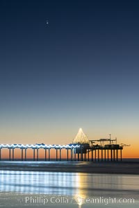
Conjuction of Saturn and Jupiter over Scripps Institution of Oceanography Research Pier at sunset, with Christmas Lights and Christmas Tree.
Location: Scripps Institution of Oceanography, La Jolla, California
Image ID: 36616
Location: Scripps Institution of Oceanography, La Jolla, California
Image ID: 36616
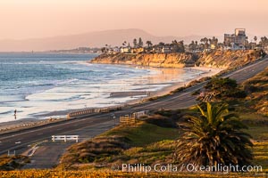
Carlsbad Coast Highway Sunset, Terramar and North Ponto to Oceanside with Camp Pendleton in the distance. Rising in the distance is San Onofre Mountain (1722') topped by a tall signal tower, one of the southern peaks in the Santa Ana Mountains.
Location: Carlsbad, California
Image ID: 37478
Location: Carlsbad, California
Image ID: 37478
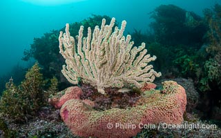
Pink Sponges Encrusting Rocky Reef alongside various species of algae and gorgonians, San Pedro Martir Island, Sea of Cortez.
Location: Isla San Pedro Martir, Sonora, Mexico
Image ID: 40374
Location: Isla San Pedro Martir, Sonora, Mexico
Image ID: 40374
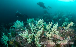
Gorgonians on Lush Rocky Reef, San Pedro Martir Island, Sea of Cortez. Gorgonians are colonial filter feeders, spreading their branches into the currents flowing over the reef in order to gather passing bits of food.
Location: Isla San Pedro Martir, Sonora, Mexico
Image ID: 40408
Location: Isla San Pedro Martir, Sonora, Mexico
Image ID: 40408
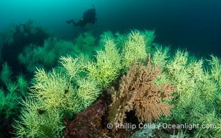
Black Coral on Rocky Reef, Unidentified species, isla San Pedro Martir, Midriff Islands, Sea of Cortez, Mexico.
Location: Isla San Pedro Martir, Sonora, Mexico
Image ID: 40411
Location: Isla San Pedro Martir, Sonora, Mexico
Image ID: 40411
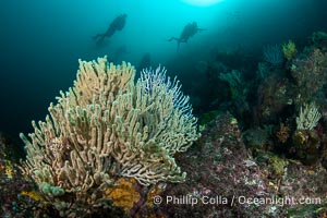
Gorgonians on Lush Rocky Reef, San Pedro Martir Island, Sea of Cortez. Gorgonians are colonial filter feeders, spreading their branches into the currents flowing over the reef in order to gather passing bits of food.
Location: Isla San Pedro Martir, Sonora, Mexico
Image ID: 40415
Location: Isla San Pedro Martir, Sonora, Mexico
Image ID: 40415
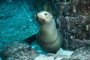
California sea lion with scar around neck from monofiliment fishing line entanglement at Los Islotes in the Sea of Cortez, Mexico.
Species: California sea lion, Zalophus californianus
Location: Sea of Cortez, Baja California, Mexico
Image ID: 31234
Species: California sea lion, Zalophus californianus
Location: Sea of Cortez, Baja California, Mexico
Image ID: 31234
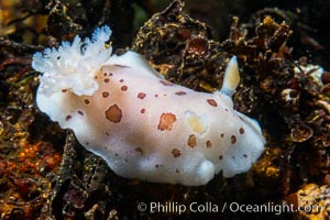
Spotted Leopard Dorid, Diaulula odonoghuei, Vancouver Island.
Species: Spotted leopard dorid, Diaulula odonoghuei
Location: British Columbia, Canada
Image ID: 34338
Species: Spotted leopard dorid, Diaulula odonoghuei
Location: British Columbia, Canada
Image ID: 34338
